
Microphysics in Cumulonimbus Clouds

|
CbClouds.jpg: One of the two ways inside clouds to generate precipitation is called "cold process". A necessary precondition for this process is that the clouds have a significant vertical extension. This is e.g. the case for thunderclouds which can reach from an altitude of 1 to 2 km up to the region of the troposphere of 10 to 12 km (in the tropes up to 18 km). The aerosol particles are the "nuclei" onto which water vapour can condense to generate cloud droplets (see "Hydrometeors" at the bottom). Once formed the cloud droplets are quickly transported to large altitudes by strong vertical winds inside the clouds. If the cloud is cooler than -10 deg C icing occurs. Due to the
low vapour pressure of water above ice a more effective absorption
of water vapour is achieved by ice crystals compared to water droplets.
This means that the ice particles in mixed phase clouds grow faster
than co-existing water droplets might do at the same time. In an
extreme case the liquid droplets even evaporate and the released
water vapour will be "consumed" by the ice-crystals (Wegener-Bergeron-Findeisen-Effect). If the ice-particles have grown sufficiently, they will sediment inside the cloud against the updraft. While migrating downwards they enter regions with temperatures above the freezing point. Then the ice particles melt. The cloud droplets formed that way are now larger than the original cloud droplets carried upwards. If these larger droplets coming from the melting process reach again a region inside the cloud with strong updraft, they will be lifted once again - now as heavier droplets. The anew icing of the larger droplets and also the agglomeration of small droplets by riming leads to the formation of "graupel cores". If the graupel cores become heavy enough by agglomeration of under-cooled water droplets or ice particles, they will also sediment inside the cloud. Again they can melt at temperatures > 0 deg C. So the "hydrometeors" can oscillate several times up and down in vertically extended clouds. Taking into account that the vertical winds in such clouds achieve updraft velocities up to 60 m/s hailstones with diameters of 10 cm and more can be levitated. Hence sometime the hailstone will become so large that also the strong updraft within the cloud cannot hold the object anymore. |
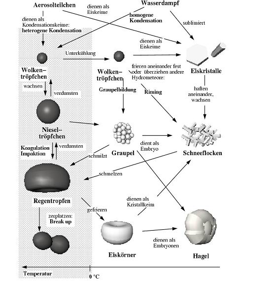
Then the hailstones drop from the cloud and hail or graupel precipitation occurs. If the temperatures below the cloud are high enough the hailstones will melt again on their way to the ground. We observe this precipitation as cold rain which is especially in hot summer days associated with vertically extended thunderstorm clouds. By this means the so-called "cold precipitation" arises in the earth's atmosphere. Hydrometeors.jpg: In the air always aerosol particles exist. They are major factors for the microphysical processes in clouds related to the different hydrometeors. In the case of weak super-saturation with water vapour as it exists in the atmosphere, water vapour can accumulate on some of these aerosol particles. This process is called "condensation". So the aerosol particles are covered more and more with water until a real cloud droplet with an aerosol particle core is formed. (If the material of the particle is completely water-soluble, sometimes also totally liquid cloud droplets are generated). Under atmospheric conditions the process from the dry or the swelled aerosol particle in humid environment to a small cloud droplet takes place in milliseconds. When the cloud droplets have once been formed, several other microphysical processes occur inside the cloud. The most important ones are summarized in the scheme. Due to further condensation small cloud droplets grow to larger droplets or "drizzle droplets". When cloud droplets are swirled in turbulent cloud air and collide with each other, then they merge and even larger droplets - the full sized cloud droplets - are formed. The generation of cloud droplets as a consequence of interaction of aerosol particles and gaseous water vapour is called "heterogenous nucleation". This is the sole fundamental process within terrestrial clouds which leads to the formation of cloud droplets. The droplets which occur inside the cloud are around 100 µm in size. Because of their low deposition velocity they are too small to form precipitation. The small droplets are also not able to grow only by absorption of water vapour to droplets with dimensions in the millimetre range which allow precipitation - that means fast enough sedimentation.
|
Therefore there has to be another process to be responsible for the formation of precipitation. The "warm process" of rain formation occurs, when cloud droplets with diameters of 100 µm collide with each other and merge. This process is also called "collision-coalescence". By this means larger droplets are generated which drop faster than the smaller ones in their neighbourhood. On their way downwards the larger droplets "catch" further droplets and so they grow even more. If the process of collision and coalescence goes on sufficiently long, droplets which are capable for precipitation are generated. When they grow gradually up to 8 to 9 mm or more, they burst during their decline, since the droplets become aerodynamically instable and they oscillate more and more until they finally burst. When the temperatures inside a cloud falls below the freezing point of pure water then the cloud droplets are under-cooled, but they will not freeze yet. Only at extremely low temperatures the small cloud droplets freeze at last. When frozen cloud droplets - that means small ice balls - collide with liquid, under-cooled droplets a process called "riming" occurs. Here the under-cooled droplets freeze at the frozen object. When the riming goes on, "graupel cores" are formed. Hence the atmospheric aerosol particles do not only support the formation of cloud droplets. Some special aerosol particles can serve as so-called "ice nuclei". For example, Cirrus clouds consist of atmospheric ice-crystals which are formed at these aerosol particles at sufficiently low temperatures. If the ice-crystals grow by further diffusion of water vapour, ice particles in the "mm-range" can occur within the Cirrus clouds. When ice-crystals collide at adequate temperatures, they can stick together and grow even more. "Snow flakes" are generated when some or even several hundred of those ice-crystals agglomerate.
CbClouds: S. Borrmann, Presentation 11/27/2003 |
![]()